Performing an archaeological geophysical survey is a complex process. It is important to appreciate that unmarked burial surveys form only a small portion, albeit an essential part, of a complete investigation when identifying undocumented graves.
At GeoScan, we pride ourselves on providing a thorough and accurate service for archeological geophysical surveys.
We utilize a multiple method approach to the detection of subsurface burials and features. We employ highly trained and detail-focussed data interpreters to ensure high quality in our interpretation delivered to clients. This is especially important when dealing with sites of a highly sensitive nature such as unmarked or undocumented graves.
This article will focus on the major steps taken when undertaking a comprehensive unmarked burial survey.
Site identification & preparation
The first and foremost important step before applying archeological geophysics is to gather as much information regarding the history of the site, nature of the potential burials and ground conditions/geology.
In the case of First Nation burial sites, the community elders and knowledge keepers are the primary source of information. We specifically take direction from communities to ensure that our survey procedures are conducted with respect for spiritual and cultural requirements.
A very important stage to any archaeological survey is the initial area identification. It can directly affect the efficiency of the project, and help to increase the quality of the findings.
Due to the nature of the data collection and varying subsurface conditions, it is inefficient to survey large areas of ground blindly. The focal point therefore should be narrowed down to a small area (ideally under 1 acre) before work commences. Larger areas can then be expanded out from the initial area if necessary.
Once all evidence is gathered, the location that requires detailed investigation will be agreed. At this point the preparation of the area continues. The area in question would need to be cleared of vegetation, where possible, to provide access to the ground surface (not containing any obstacles such as buildings or vehicles).
If the area is cleared for easy access, it makes the process of gathering data far smoother
If access to a relatively flat ground surface is not possible then ground coupled methods such as Ground Penetrating Radar (GPR)) cannot be used. Instead we can employ Electromagnetic Conductivity (EM) and Magnetometry (MAG) methods however, this will limit the accuracy of the ground model results and therefore provide less confidence in the final interpretations.
Data collection
Most survey designs will follow the individual method’s guidelines, regardless of the combination of methods used. Grids are regularly used with Ground Penetrating Radar when doing archaeological geophysical surveys, and it makes sense to collect Electromagnetic and Magnetic data along these same parameters. Most projects are complete in this linear pattern, following the grid lines marked clearly in the area of focus.
The order in which these methods are used is not important, but for best results, they must cover the same area – this helps in the final interpretation as different datasets of the same location can be compared and contrasted to build the best overall geophysical model of the features detected.
Drone footage gathering data along lines within in a grid, using Electromagnetic Conductivity (EM)
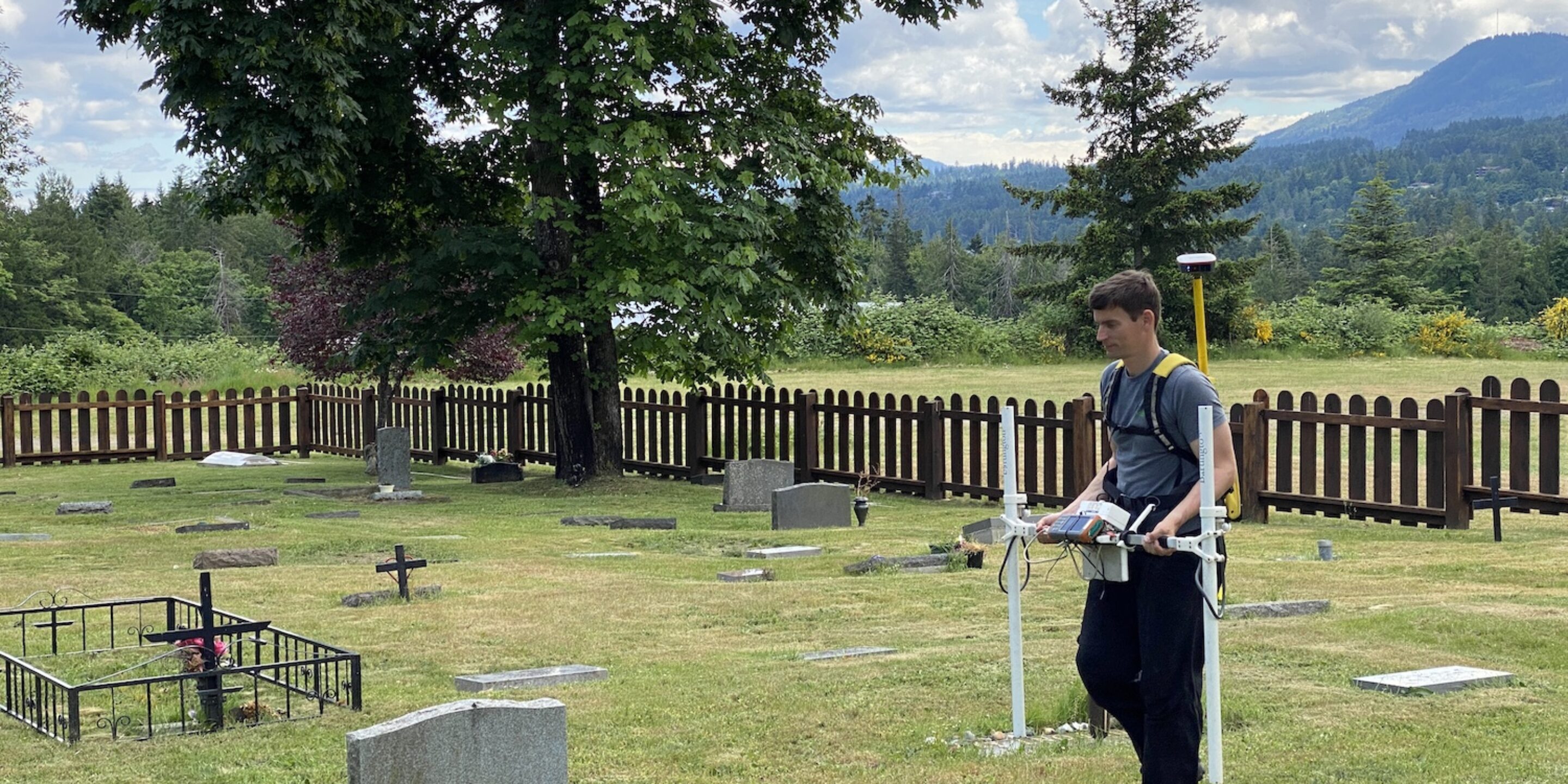
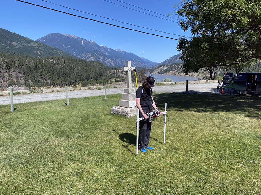
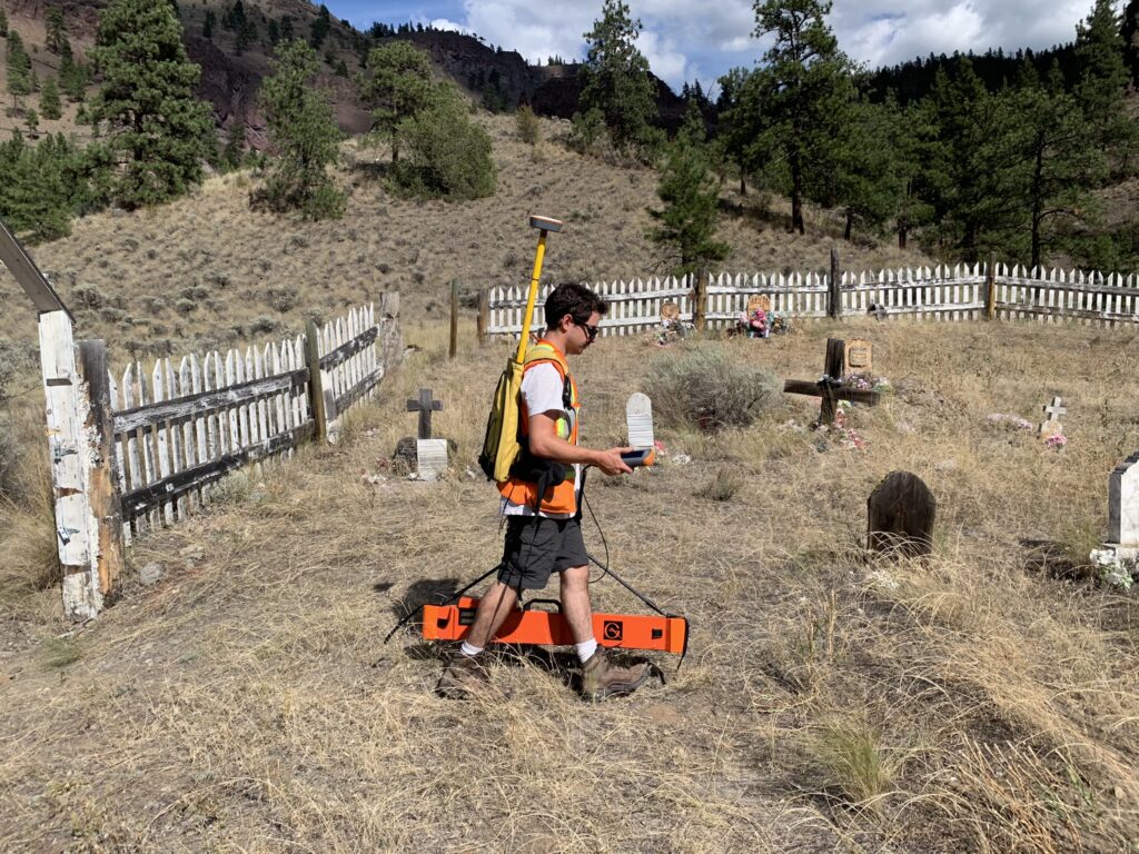
Once the data is gathered, we use a total station or survey grade GPS to georeference the survey area. This allows us to map out the data with high accuracy, which is vitally important to ensure that the final map deliverable is representative and ultimately usable. This ensures that potential graves remain undisturbed or to allow for them to be verified in a culturally appropriate and sensitive manner.
Using drone footage to generate orthophotos of the area can benefit interpretation and understanding in the context of the surroundings.
Then finally, using our specialist software we create a digital surface model. This is very similar to what’s commonly know as a LiDAR survey, but would include any data interpretation of the subsurface, as well as the ground level.
The equipment used
Three of the most commonly used methods in Archaeological Geophysics are GPR, EM, and MAG. All are non-invasive but have differing capabilities, which is why they compliment each other in practice.
- Magnetometry (MAG) – A handheld piece of equipment that can detect and map ferromagnetic material that disturbs the earth’s magnetic field. This method is useful due to the area of ground that you can cover in a short space of time. Magnetometry can be regularly used to locate remnants of abandoned oil and gas wells, or to pick up the magnetic signatures of various human related activities, such as hearths associated with previous dwellings, such as pit houses. We use a High Resolution Fluxgate Gradiometer, with a resolution of 0.1 nanotesla (nT).
 A Magnetometry survey
- Electromagnetic Conductivity (EM) – Another handheld sensor that contains a pair of electrical coils that are carried above the surface. This equipment responds to variations in ground conductivity within the shallow subsurface caused by increased water content and the presence of metallic and ferromagnetic materials and minerals. The coil spacing is typically between 0.5m and 1m with an operating frequency of 14.5 kHz.
 An Electromagnetic Conductivity (EM) Survey
- Ground Penetrating Radar (GPR) – A cart or drag based system that works by emitting harmless electromagnetic waves from a radar antenna which transmits through the ground. As these waves encounter changes within the ground (due to buried objects, variations in horizon geometry, material, mineral and/or water content) they ‘reflect’ back a signal to the control. The control unit collates these continuous measurements and displays a profile of the subsurface, graphically. You can think of this as a profile image of the ground, collected beneath the path of the antenna, a bit like a slice through a cake. Generally, we use antennas with a centre frequency of 400MHz as they provide a reasonable depth penetration and resolution in the produced image. For shallower investigations we have higher frequency antennas that provide better resolution (i.e. can “see” smaller features) and conversely, we also use lower frequencies for deeper imaging albeit with reduced resolution.
Drone footage collecting Ground Penetrating Radar (GPR) data
Each piece of equipment is calibrated on the site to ensure absolute accuracy before data collection. To learn more about the equipment used in Geophysics, refer to our blog article ‘Why it’s important to use multiple methods in Archaeological Geophysics’.
Data Interpretation
Once all datasets have been collected we begin a thorough process of organizing, cleaning, visualizing and finally simultaneous interpretation.
We layer the products of all methods together spatially using dedicated mapping software. Magnetometry and Electromagnetic datasets are analysed from the top down, with signals pertaining to potential anomalies and features picked out of the produced data images.
For GPR, the interpretation process is more in-depth. Top down images (plan view) are generated from the multiple GPR profiles at consistent depth intervals, 0.1m, 0.2m, 0.3m, etc… until the clear GPR signal ‘runs out’. These plan view images give us a clear view of geometric trends of subsurface objects and anomalies, this is a great way to visualize GPR data (Fig X.) and generally where most archeological geophysical technicians would stop their process, but some features can be masked or missed in this process. Our technicians drill down into the details in the data much further to ‘pick’ features at the raw “side-view” profile level.
Each individual GPR line is processed and assessed visually and potential grave features are marked.
This can be an extensive, labour intensive process (for example: a typical square acre plot consists of 252 individual lines that are over 63m long if sampled at 0.25m – our standard) that uses our in-house proprietary software but we have found the results to be much more reliable.
Each method (MAG, EM, GPR) provides a wealth of different information regarding the nature of the subsurface but it is in drawing conclusions from all of them together whereby the best possible interpretation can be achieved.
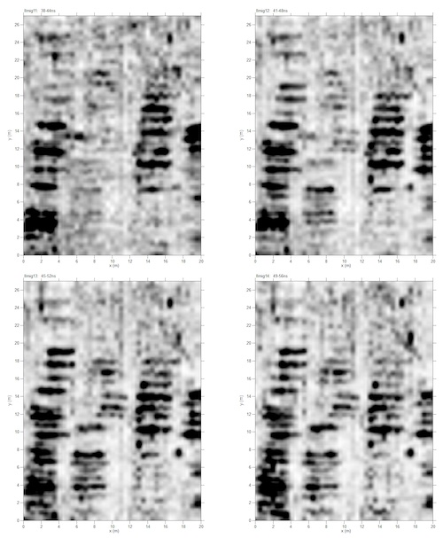 Fig X. – Example depth slices from the same site taken from four depths showing graves from a “western style” burial site. Rows of dark features indicate individual graves.
 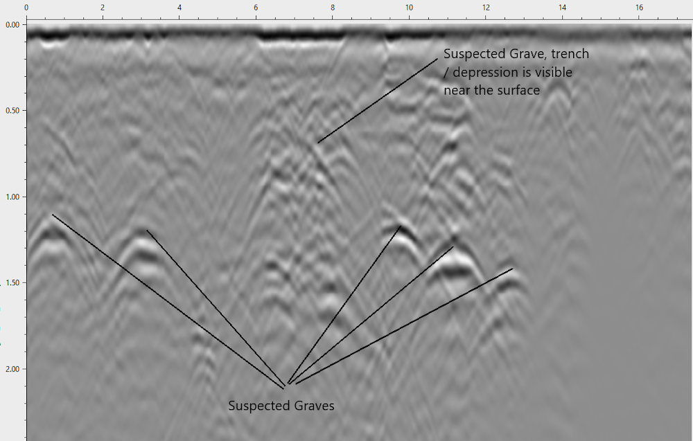 GPR-B-scan-Example-Annotated
Final report
Our final unmarked burial survey written report includes an overview of the survey procedure, details of all equipment used, full methodology for interpretation and the combined results of the survey.
The combined interpretation for grave detection is presented in a series of maps showing the potential grave locations, geometries and depths along with a ‘confidence rating’ depending on the clarity and combined attributes of the geophysical signatures. In addition we take and include annotated photographs of the site and additional limitations and notes.
Please see several examples below of interpretive maps.
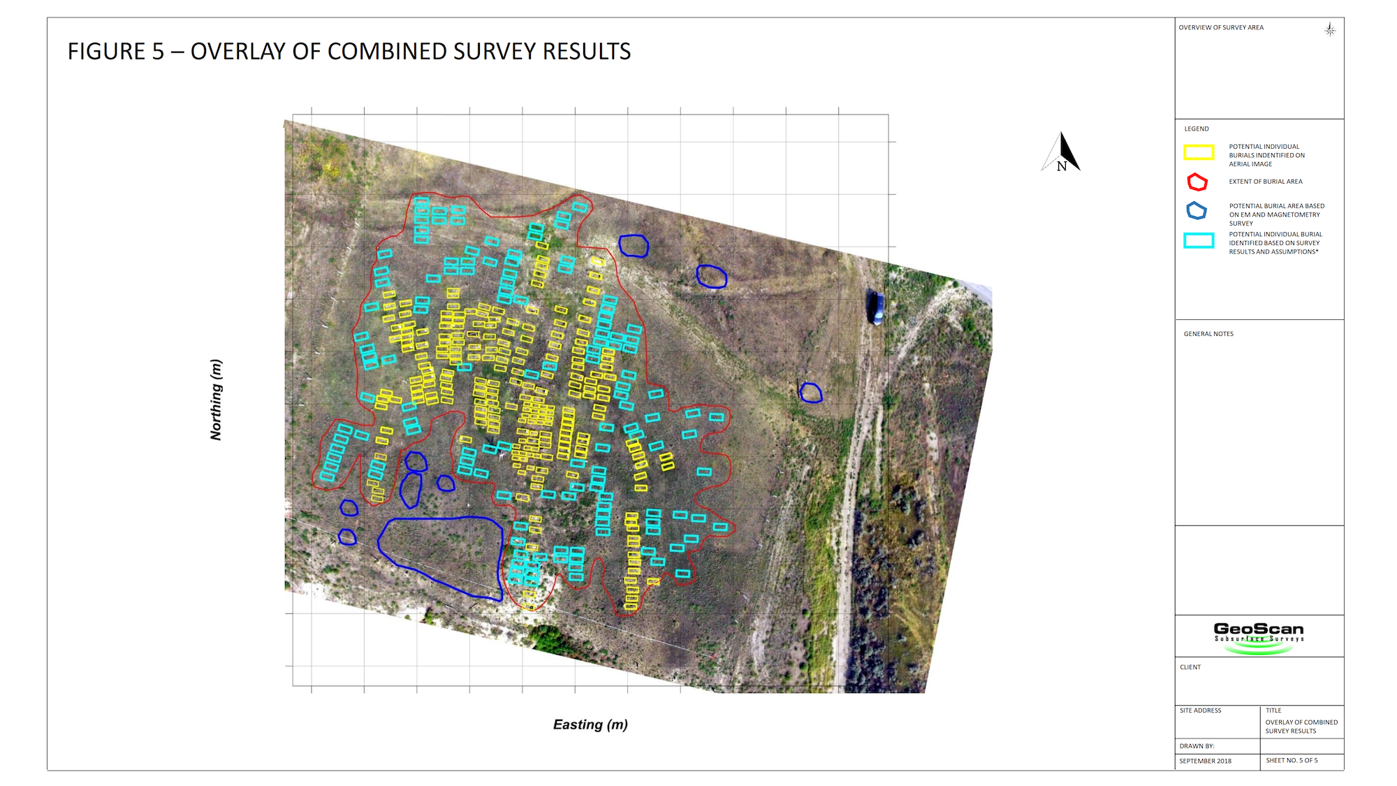
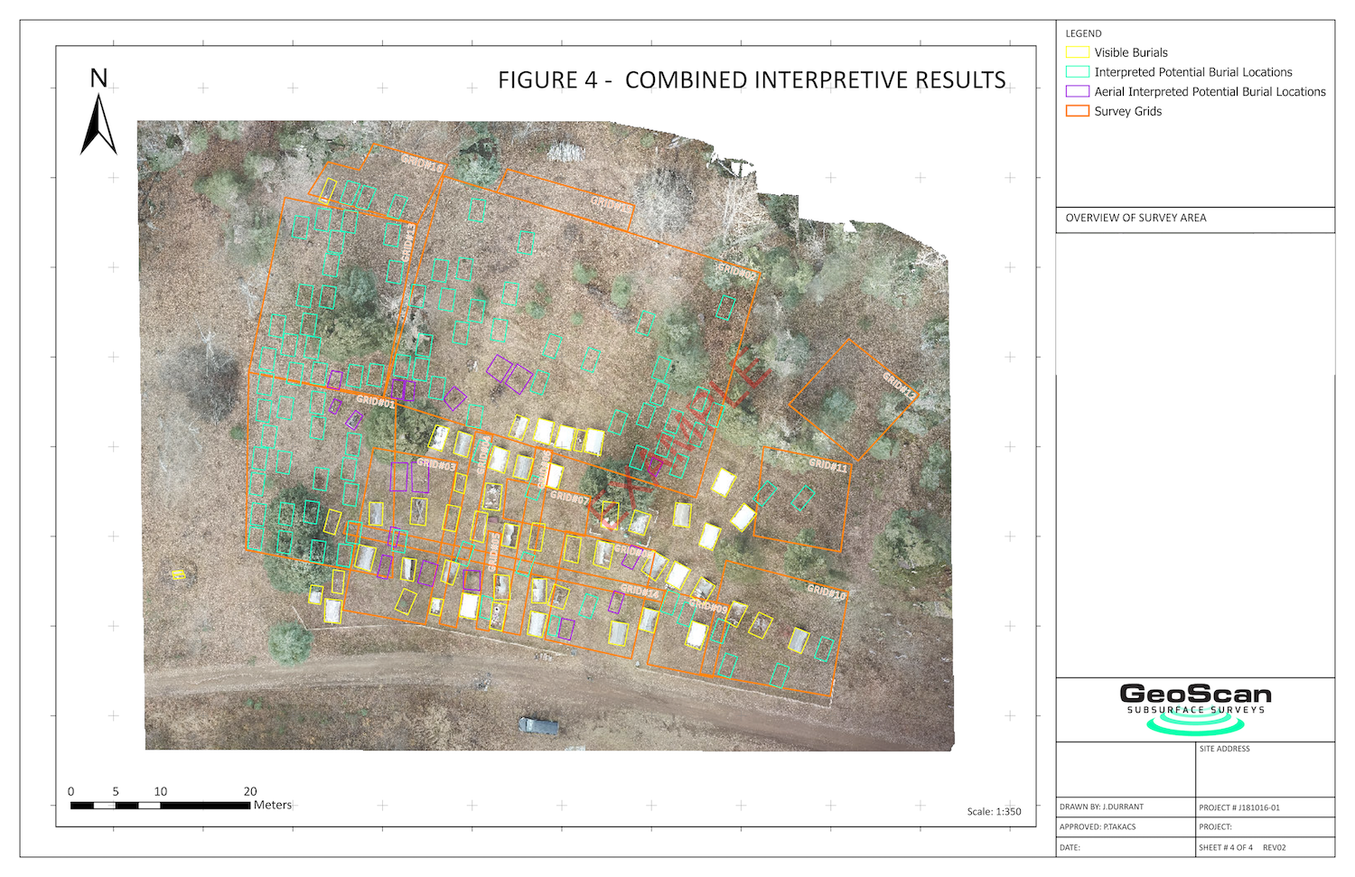 Unmarked Graves First Nations Cemetery Example – GPR, MAG & EM
What’s next?
A common question is “what is done with these results?”
Once the client has reviewed the findings, they will have various options ahead of them. If they want to verify the findings by excavating, then at this point they would engage an archaeological company to take this further. In some cases though, communities are content knowing further information about suspected areas of interest, and leaving the area untouched.
Whatever the results, sensitivity is heightened when revealing buried archaeological features, sites and landscapes, so survey quality is an absolute priority.
If you’d like to learn more about how we use these methods in our work, especially whilst completing unmarked burial surveys, please head to our blog pages. If you’d like to speak to one of our technicians about a project of yours please contact us.