
Multi channel GPR can cover large areas within a short period of time, collecting immense amount of data for various applications. It can be customized for special applications while its disruption of any current operation is minimum.
Multi channel ground penetrating radars use synchronized single channel bi-static GPR antennae in various array layouts. These arrays generally are intended to be used for large scale data collection, but some of them can be uniquely customized to accommodate various project specifications.
GeoScan has used several types of multi channel GPR arrays, including the IDS stream C and GSSI multi channel systems. After thorough testing, evaluation, performance testing and cost-effective analysis, we concluded the best option is a customisable modular system that can be configured to suit any project requirement. With its capabilities and using our custom-made frames we can prepare for every different scenarios.
How It Works
Multichannel GPR systems have been used for a couple of decades, but early systems did not deliver quality results due to the lack of synchronization of the individual antenna responses. In the last 10 years, this asynchronous response has mostly been solved by technological advancements and we are witnessing a wider acceptance of multi channel GPR systems in various industries.
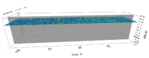
Figure showing an example processed data set. The area covered was measured approx. 100m x 50m. The final results showed the exact location of each drain pipe and the depth of the bedrock beneath the survey area.
Although the multi channel technology has been improved immensely, the detailed understanding of the GPR data collection is the key to successfully and efficiently collect data for every project.
Typical applications of a multi channel GPR system include:
Utility locating with limitations

What We Use
GeoScan uses a modular array system with several optional frequencies that can be setup for virtually any line spacing. For the most accurate spatial reference we are using survey grade GPS. The typical applications for each frequencies are:
- 1.6GHz array system: asphalt thickness and concrete inspection surveys.
- 900MHz array system: shallow subsurface utilities, archaeological surveys.
- 400MHz array system: utility locating, bedrock and void mapping or shallow geological mapping.
- 200Mhz Array system: deep utility locating, bedrock & void mapping or shallow geological mapping.
The data collection is usually completed using a vehicle mounted system, but for areas with limited access a hand-pushed system is also available.